-
-
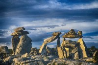
My first impression as I surveyed the location was that was standing amid an ancient communal repository of carcasses. Even the sky had ominous tonality.
-
-
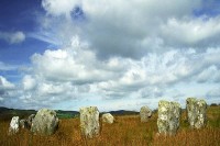
An Irish photographer had photocopied a map from a publication called Antiquities of the Beara Peninsula and were set for an adventure. We hiked across private fields and clambered over fences searching for this stone circle. With all our gear it was no easy feat…and at last we found Reenascreena…and we were the only ones there! The heavens were obviously pleased with our discovery and provided exuberant clouds that compounded the drama of our find that is captured with this image.
-

-
Located in West Cork, this is probably the most well-visited and accessible stone circle. It is over-run with tourists and that diminishes the mystique. Fortunately, we experienced the intimacy of mystery at Reenascreena and it is fascinating to note the preponderance of stone circles. This one dates from the Bronze Age and an adjoining cook pit shows evidence of being used into the 5th century. Today there are camping facilities nearby.
-

-
Like Ansel Adams, I will frequently take my data in the field and create my image in the darkroom. Adding to the aura of drama and mystery, I recreated my photograph of the Drombeg Circle into a black and white print. It immediately sparked reminiscence of the tonality of Ansel Adams’ photograph, Moon Over Hernandez and I knew I created something special!
-

-
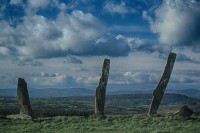
This is the Galantines South Stone Row, aka Glouthane. Like old burial markers,
these stones stand…the remnants of a vital ring of erect stones that drew people together to make sense of their relationship to Nature and the universe.
-

-
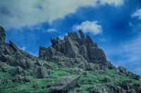
The lush green farmland covered the earth like a quilt of assorted green fabric. The softness of the earth contrast greatly with the rock formations.
-
-
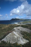
We were on this fantastic quest to photograph unmarked stone circles in counties Cork and Kerry and discovered this grouping on top of a mountain in the middle of a private pasture about 1 km northwest of Castletownshend. The owner of the farm did not welcome our trekking through his property because it was grazing grounds for his herd of bulls. We didn’t see any evidence of bulls and found entry to the grounds away from his sight via a public school parking lot. All we had to do was crawl under an electrified fence…and that we did to pursue our quest. The photography expedition went remarkably well until…
-
-
…until it came time for our descent. Suddenly, I was warned not to turn around as a herd of bulls was migrating toward us. There really was a herd of bulls! With steadfast haste we crossed the field…making no eye contact and not worrying where we stepped. We just want to get under the electric fence before the bulls were angered by our presence. We exited safely and the calm of this image belies the angst of our adventure…but the photographic adventure continues with the digital interpretation of this image.
-

-
Timoleague Abbey was founded by the Franciscan order in 1240 A.D. on the site of a 6th century monastic settlement founded by Saint Molaga. The name Timoleague means house of Molaga, Tigh Molaga. Although the stained-glass windows were smashed when the English sacked the abbey in 1612, much of the architecture survives and the ruins reign gracefully over the village.
-
-
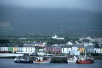
Valentia is also spelled Valencia is Dairbhre in Irish. It lies off the Iveragh Peninsula in the southwest of County Kerry and is the departure point for Skellig Michael. The houses in this harbor town and the boats in the harbor were gaily painted and brightened the overcast day…but and the following day, when we were to set sail for Skellig Michael, was much worse.
-

-
Here is a moment in Valentia that shows no indication of the treacherous and turbulent conditions that marked our voyage to Skellig Michael. This weather is clear and the boats are decked out in the harbor like a string of Christmas lights.
-

-
We were traveling through the southern coast of Ireland to the home of a relative of my travel friend and stopped for lunch at a pub situated in the center of this cove. The day was splendid and bright with expressive clouds. Everything about this setting was ideal…Bantry Bay is where the mountains meet the sea…and I believe the name of this town is Glengarriff.
-

-
Mizen Head Peninsula, rugged and beautiful, is the most southwesterly point of Ireland. Treacherous swirling waters crash these coastal cliffs as waterfalls cascade into the turbulence. These Atlantic coastal cliffs mark the most southwesterly point of Ireland and from Fair Head to Mizen Head is often romantically stated to describe the length of Ireland.
-

-
To add drama and ruggedness to my portrayal of the Mizen Head Peninsula, I re-interpreted my photograph into this black and white image.
-

-
The landscape is breathtakingly beautiful and the beach scene from Ryan’s Daughter was filmed here as were scenes from the movie, Far and Away, featuring Tom Cruise and Nicole Kidman. The bed and breakfast we chanced to stay at, boasted photographs of the owners posed with Tom Cruise, as he, too, stayed at this lodging.
-

-
The Dingle Peninsula landscape is breathtakingly beautiful and the beach scene from Ryan’s Daughter was filmed here as were scenes from Far and Away with Tom Cruise and Nicole Kidman. The bed and breakfast we chanced to stay at, displayed photographs of the owners posed with Tom Cruise, as he, too, stayed at this lodging during the filming.
-
-
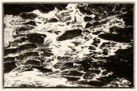
Intrigued by the patterns in the water, I created this image of the surf.
-

-
What these rocks, coated with centuries of lichens and mosses have witnesses is documented by historians and show the power of nature’s endurance. Sometimes when I am viewing something so monumental I choose to focus on a small bite-sized morsel…to visually and emotionally digest the magnitude of the vista. Such was the case with Skellig Michael. Actually, there are two Skelligs. Skellig Michael, also referred to as Great Skellig and Little Skellig…and both are renown in their own right. Skellig Michael, the larger island, is a UNESCO World Heritage Site. Little Skellig, nearby, too small for human habitation, is the second largest bird sanctuary in the world and home to more than 27,000 pairs of gannets.
-
-
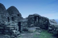
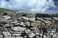
Climbing to the top of Skellig Michael was a trip into antiquity. This remote abandoned monastic complex of beehive construction, dating from the 7th century, was proclaimed a UNESCO World Heritage Site in 1996. Prior to this trip, I had not heard of either Skellig..and here I was! We swung like a pendulum, on a rope to get from the rocking boat to the landing ledge and then hugged the steep mountain as we climbed 755 feet to the top. We visited in September of 1999 and saw that archeological excavations and reconstruction was underway.
-
-
A steep climb of more than 600 steps reveals a settlement of beehive huts called clochans, two oratories, and several small terraces on a plateau approximately 700 feet above sea level. Prior to this trip, I had not heard of either Skellig and was awed by the harsh conditions that these early Christians chose to endure and by the preservation of their community.
-

-
I have a soft spot for rocks and of the thirteen surviving stones in the Drombeg Circle, this one looks like that of a stooped old man or of a toddler with a sagging diaper.
-
-
The Dingle Peninsula landscape is breathtakingly beautiful and the beach scene from Ryan’s Daughter was filmed here as were scenes from Far and Away with Tom Cruise and Nicole Kidman. The bed and breakfast we chanced to stay at, boasted photographs of the owners posed with Tom Cruise, as he, too, stayed at this lodging during the filming.
-

-
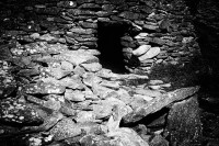
Climbing to the top of Skellig Michael was a trip into antiquity…and to the deep-freeze. The winds blew and the temperature dropped as we ventured to the remains of this remote Irish Christian monastery that was abandoned in the 12th century and relocated to the Augustinian Monastery at Ballinskelligs in County Kerry on the mainland. What these rocks, coated with centuries of lichens and mosses have witnesses is documented by historians. That they remain shows the power of nature’s endurance. Prior to this trip, I had not heard of either Skellig. We swung like a pendulum, on a rope to get from the rocking boat to the landing ledge and then hugged the steep mountain as we climbed 755 feet to the top. We visited in September of 1999 and saw that archeological excavations and reconstruction was underway.
-

-
I am a great fan of NIK filters and use them to recreate my reality. Although these images were originally taken with film and scanned with a Nikon Super CoolScan5000, each black and white image was made using NIK software.
-

-
Here is a closeup of the beehive huts where one could almost touch the clouds.
-
-
Here is another close-up of the beehive huts called clochans. Prior to this trip, I had not heard of either Skellig and was awed by the harsh conditions that these early Christians chose to endure and by the preservation of their community, established on a plateau nearly 700 feet above sea level.
-
-
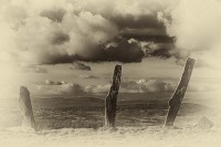
Black and white shows the stark isolation of the settlement